Image : @cyrildiabolo, 1st TNR
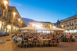
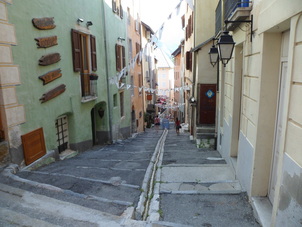
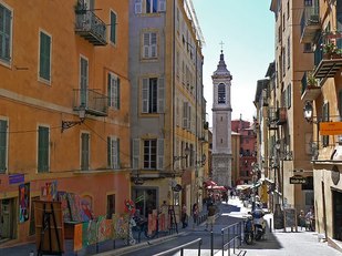
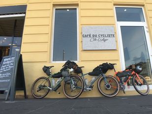
TurinTurin is a beautiful city to visit and a good place to be for the weekend before the ride if you have time. The start is near the centre so there's a chance to see some of the sights as you roll out of town. If you have have time to explore, see the 30th July 2017 update for a GPS guide short tour of the city's sights and tastes. The traditional meeting point for riders the night before the start is in Piazza Giambattista Bodoni, for a beer and pizza or pastaat Pizzeria Restaurant Alla Lettera. The route starts from the same place. The first 20km of the route is quite direct and aims to get us out of Turin relatively quickly - as nice as Turin is, once we're riding we're usually thinking of the mountains more than the cities. The route heads north from Turin at first and passes fairly close to the airport and train stations so starting there might simplify logistics if your time is limited. Images : lower at Alla Lettera restaurant, @rotgans_photo |
For a glimpse of the nightlife of Turin, take a look at the short film 'Una Notte a Torino' by Giorgio Blanco, friend of Sergio, 'our man in Turin':
|
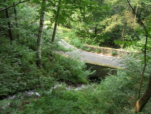
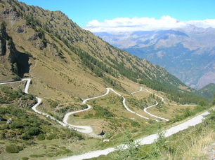
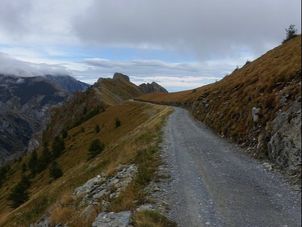
colle delle finestreThe superbly photogenic Colle delle Finestre is a highlight of this ride. It gains 1700m height over 18km and the upper 8km is a dirt road. The gradient is consistent as this road was built by the military in the 18th century, apparently they could drag artillery up a 9% slope. The climb changes from narrow wooded roads with switchback after switchback and over a stream flowing under old stone bridges, to a dirt road from heaven for the last handful of kilometres and 700m of climbing. It's been ridden by the Giro d'Italia a few times but don't let that make you think it's easy-going on skinny tyres - it was smoothed out especially for the Giro and within weeks was back to the more usual conditions. At the col there is a fort and monuments to Giro stage winners. The views are expansive and there's only a couple of km of tarmac between here and the famous Strada dell'Assietta. |
|
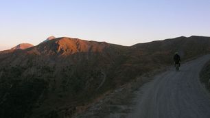
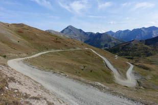
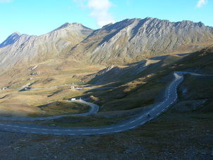
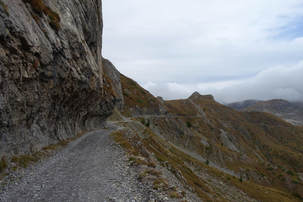
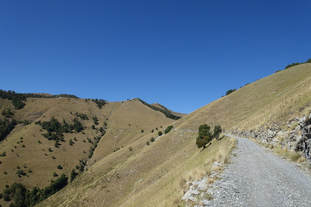
Strada dell'assiettaAn Italian military route over 120 years old, the Strada dell'Assietta rises and falls between a number of dirt road cols at 2,200m to 2,500m altitude above the Susa valley, navigating 30km or more of ridges and mountain side with expansive views. The road then descends towards the ski town of Sestriere, then the restaurants and cafes of Cesana Torinese before the border crossing into France. It's an incredible ride. There is a refuge along the way and other paths that can take you to old military buildings and forts, one reached by even higher roads within a few tough kms of the GPS-marked route. Some of these points are noted in the cue sheets.
The main track of the Assietta is not a road less travelled though. It's famous for good reasons so the track can be in a wide range of conditions depending on recent weather and traffic. Riding through here mid-week outside of the main season means it's quieter and late night or early morning riders may be rewarded. Image : lower @rotgans_photo |
|
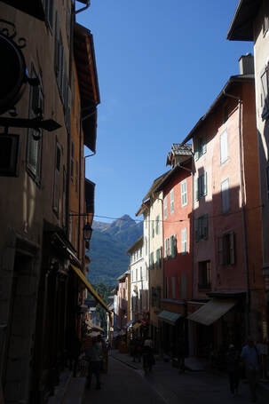
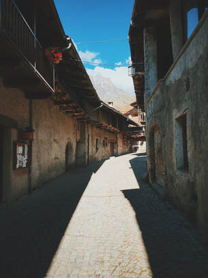
Briancon old townBriancon is a gateway to many parts of the French alps and on one of the two roads into the north west corner of Italy. It's the highest city in France and reputed to have more days of sunshine a year than any other area in the country. The fortress is a main feature of the city and was built by Vauban, military engineer of King Louis XIV, in the 17th century to fend of the invading Savoyards. As part of the Fortifications Of Vabuan it's a UNESCO world heritage site. It's clearly visible from a long way outside the city as you descend towards it from the Col Montgenevre. We'd ridden past this part of Briancon a number of times, like most riders headed for the Col Izoard or the Cols Lautaret and Galibier. As we rode into Briancon this time we decided to take the turn on the left and have a look around the old town area. It has a beautiful church and a steep main street with small shops, cafes, ice cream and crepes stalls and water fountains. The route takes you down the central street and the cues include a note of where the church entry is. It's best to walk along this street and take your time but if you want to speed past the old town to the shops and onto the point where you decide on either the Col d'Izoard or the lesser-used route around the back, go for it. It's easy to follow the main road past the old town turn-off and pick up the GPS line less than half a kilometre later heading out of town on the Avenue du Col d'Izoard. |
|
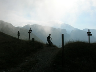
COL AGNEL / Colle dell'agnello, 2744mThe historic Col d'Izoard is a Tour de France classic that most riders will have heard of. The col that follows it on this route, the Col Agnel or Colle Dell'Agnello ('col of the lamb'), probably less so. The climb starts at around 1400m and gains 1350m - at 2744m it's the high point of the route and can see snow in early to mid September. One of many border crossings on this ride is at the col stone itself which marks the boundary between France and Italy. The Agnel/Agnello has been used in the Giro a number of times when they've climbed the steep Italian side. When climbing the French side on this route it's not very steep apart from a few short sections. Like most big climbs it does ramp up towards the top but on a good day it's not especially hard, just long. Pray for the wind to be with you though.. The descent is quite different. If the climb doesn't leave you breathless, descending the Italian side may. As the descent levels off a little you pass Chianale, a small village at 1800m. It's well worth a look around this old alpine village with traditional stone roofs and narrow cobbled streets. Image : lower, Ben Mills |
|
via del sale and rifugio don barberaThe Via Del Sale is a historic salt traders' route in the Liguria-Piedmonte area, part of a network of trade routes connecting the Ligurian coast with the Po valley and onto Provence or Turin. Being close to the French border the route was developed by the Italian military and there are old forts and bunkers on hilltops along the way. The rally takes the section to the east of the Col Tende and follows it with other tracks through similar terrain and landscapes. This is a longer off-road section than most in the rally. It's optional but can be seen as an achievement to have planned and ridden in a way that gives the time needed for this part of the route, and the views will reward you. The terrain is stony but not too difficult to ride and although it's a popular route for 4x4s and sport-touring motorcyclists, the tracks will be quieter in September than the peak season of July and August. It could be wise to descend the col more directly to Tende in the worst weather as the road is over 2000m for the majority of its length with almost no shortcut options although there are some potential shelter points along the way. The shelter point to look forward to is the Rifugio Don Barbera. At 2079m up at the head of a valley it's in a stunning location where you can rest and see the route stretching out high on the hillside opposite. It will be open in early September and the food is very good indeed. Plan ahead and it's a great place to stay. The rifugio is noted on the route cues and the turn-off from the main track is easy to find. |
|
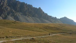
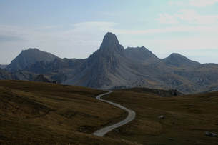
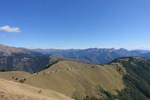
'Little Peru' and rifugio GardettaA high-altitude section of military road, nicknamed after the view of a prominent rocky peak on the edge of the high basin area that the track skirts the edge of. Perhaps the most celebrated section of the rally? There's two ways into this section, both mapped and noted as part of the route files. The original 2015 route will suit those with a willingness to push for a while under the view of a machine gun bunker that guards the valley, this route is where the high area opens out in front of you as you crest the col. The other route is a memorable road, a tough but mainly tarmac climb with a different but equally impressive view of the peaks that dominate this area, visible from a lower position on the climb. Neither are easy but both equally reward the rider for the effort needed to get up here. The Rifugio Gardetta is a welcome base for riders. The hospitality is as good as the food - highly recommended. |
|
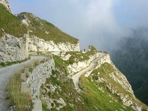
fort DE LA FORCA and the col de turiniWhen French-Italian relations deteriorated in the late 19th century work began on the Fort de la Forca, what is now the ruins of fortifications built on this high point above the Col de Turini. The hill top at just over 2000m in the Mercantour Park looks toward the Italian border and overlooks the Vésubie and Roya valleys so was considered an important strategic point, important enough that it was occupied by the German army during the Second World War. Getting here isn't easy, as you might expect for a hill fort. It's a long but worthwhile climb, mainly on gravel tracks, from wooded terrain to an open hillside traverse. On a good day you can see the sea from the top. There's a loop around the fort that could add a couple of fairly flat kilometres if you're feeling fresh and want to see the full 360 degree panorama of the area, it simply brings you back onto the GPS route. Tracks to the fortifications on the hill top are signposted. From the Col de Turini it's downhill for a while past the lovely village of Moulinet and a unique chapel further along the road. If you're a true rally fan you'll recognise the descent from the top of the col as part of the classic 'Night of the Long Knives' section of the Monte Carlo Rally (you will be descending some or all of the road that Petter Solberg is driving up in this video, depending which route you take). There's a great Monte Carlo Rally memorabilia bar on the col itself. The rally route now includes an option for a faster finish after you've made it as far as the Col de Turini - 50km plus of tarmac descending all the way to the coast. |
|
NiceIt's fair to say the whole area may come as a culture shock after days in the hills. Unwashed cyclists and the glitterati of the Med make an amusing contrast. For those that prefer to avoid as much of the traffic as possible there's a route from Turbie that takes you to the old town area of Nice while avoiding the coast until the last kilometre or two along the Promenade des Anglais, with a cycle lane on the promenade it's one of the easiest ways to the airport. The old town is worth spending some time in, it's the nicest part of the area for many and the route includes a loop around this area. It's close to the Nice Ville train station for anyone needing the train back to Turin.
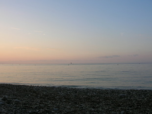
Be aware that 99% of this area is private and bivi spots are almost non-existant so prepare to sleep hidden like a hobo or shell out for a hotel. If you want to bivi before Nice the dirt section after the top of the Col Braus is a good bet. Wherever you decide to make that ceremonial dip in the sea to mark the end of the ride, try to make it to Cafe du Cycliste in Nice if you can - it's a traditional finish line of sorts and a good place to meet other riders. Image : lower, Ben Mills |
|
THE DECISION JUNCTIONS
|
(updated June-July '21 for route used for 5th TNR onwards)
By the time you get to Nice you'll have made a few route choices. These route choices are a part of what makes this event format less about record times and racing and more about a wing-it approach to riding with the pressure off. There's no right or wrong choices, there's no best or proper route. There's also no real reason to take the recommended routes - exploring is always good. The route info is just a guide to a great area to ride, no more than that. Knowing where the options are will help route-planning with the route files and cues, especially for anyone riding a road bike or a bike with limited off-road ability. In order of appearance, these are the route choices or shortcut alternates you'll have along the way - with enough info to help you plan a little but no pictures or major spoilers for those who want to find out more as they ride. |
|
|
After Briancon - the Col d'Izoard or 'The Backside of the Izoard' decision (routes 2.1or 2.2) When we rode from Turin to Nice in 2015 we wanted to see where the small road out of Cervieres went. It was clear it was a dead-end road and it looked quiet, what we weren't sure of was what the route over the Col de Peas that linked this road with a track on the other side of the Col d'Izoard would be like. We found that much of track is too steep to ride and the final path up to the Col des Peas does involve carrying your bike, so if you can't shoulder your bike for more than 50-100yds at a time this section will be difficult but perhaps not impossible. Despite being able to carry our bikes and wearing MTB shoes some minor cursing at that point gave the section the name 'Backside of the Izoard' but that's a disservice to its beauty and remote feel. The mountain bikers will like the descent and the dirt and stone track down to Chateau Queyras is nice. The other route, the Col d'Izoard, needs no introduction. For anyone on a heavy-loaded or thin-tyred bike it's the most likely route and it's a classic road for good reason. At the Colle Sampeyre - the Varaita-Maria cut-off shortcut - aka 'The Death Road' (SCR2) The Colle di Sampeyre is reached after a long climb to over 2000m and the following section of high altitude track, the Strada Cannoni, is fairly long and in places rougher than most other off-road sections of the route. It's on a high ridge and is loose and quite stony on some of the descent sections. It's fair to say that one rough downhill section of around 3-4km is MTB terrain that, although not very steep, will be a serious test (or a walk) on a lighter-tyred bike. For riders on thin tyres or in the case of bad weather there's a tarmac cut-off route that takes around 40 miles off this section. The cut-off descends a valley with dramatic steep-sided rock walls. A clue or a warning though - it's an 'exciting' road for sure. Take care. Note, this road is not advisable during or after periods of heavy rain due to the high risk of rockfall onto the road - use the SP335 to Stroppo to descend from the Colle di Sampeyre instead. Either way up to the 'Little Peru' section (routes 4.1 or 4.2) The original route took us up a steep off-road climb that starts just past the tiny village of Chialvetta. Some of the climb could be possible to ride on a low-geared MTB but for us it was a mostly a push with some carrying when the track got narrow and loose. It's still a great area to be and the views both on the way up and from the col make it worth the effort. If you'd rather pedal up all the way there's an alternate that climbs higher on tarmac before gaining the track, it will be a quicker climb but it's certainly not an easy one. It enters the upper section from a different location but only misses a small amount of the dirt and stone road there. It's a stunning road in it's own right and could perhaps become the main route. Time and feedback will decide that in future years. There's also a cues-noted but unmapped (since it's so easy to find) option along this section, to head up to the Colle dei Morti / Colle Pantani from the junction of the end of the track and the road descent. A large monument to one of Italy's most famous climbers is at the col, just ride back ~3km to the route afterwards. The Colle di Tenda / Col Tende decision (routes 5.1 or 5.2, updated for '23) The junction as described on the Intro page. This is a bit of a dilemma since both routes are great, your decision may come down to time or weather. The faster route (5.2 in the route files) uses the more well-known old route down from the col, a small road with many switchbacks. It's been repaired since the storm damage of 2020. This section will cut half a day at least off the overall route time when compared to the longer Via del Sale route option, possibly a full day. The longer section (5.1), the Via del Sale, is detailed above. It's an achievement to have managed your time well enough to complete this beautiful section. It offers the chance to ride a longer and more remote dirt and stone strada and also opens up another optional side-trip for anyone with time-a-plenty. The Refuge Don Barbera is part way along the Via del Sale, recommended as a place to stop for either a coffee or a meal and a bed (call ahead perhaps). The eastern half of the Via del Sale used on the route isn't particularly rough, just stony and loose at times and some of the loose corners have long, dangerous drops off the side with no protection. This road features regularly on lists of dangerous roads in the alps and like the Assietta road there will be some motorbikes and 4x4s on the route. Once off the main Via del Sale road the route heads back towards Dalmas on some (at times, more rough and steep) stone tracks and meets up with the shorter switchbacks route in Dalmas itself. From the Roya Valley/Fontan or from the Col de Turini - shortcuts to Nice There's an additional all-downhill tarmac route to Nice from the Col Turini. By the Col Turini you'll have done all of the major climbs and the idea of a 50km+ descent will appeal to many. To some this won't be an overall shortcut as such, it'll be a time-saver here that might make the difference when deciding which way to turn earlier in the ride. Other short cuts to reach Nice from the Roya Valley via the Cols Brouis and Braus are included in the route files and were used by many riders after the Col Tende during the 1st rally. It's a nice ride and the Col Braus bivi spot isn't so far above Sospel that you can't carry cold beers up there to celebrate being so close to Nice (wrap them in your sleeping bag for the climb!). |